Common Geo-Registry (CGR)
A single source of reference information for the standardization, management and use of geographic data over time.
Problem
Information systems used to make decisions often have a different pictures of the geographies they respectively cover (i.e. people, places, and infrastructures). Within a single area, different programs collect different geographic data at different times and store them in siloed systems, leading to discrepancies and duplication of effort. This also results in decisions based on incomplete, out-of-date and/or inconsistent geographic data (e.g., spatial distribution of population and resources), ineffective resource allocation, and in the worst cases, affected populations being missed completely during times of crisis.
Solution
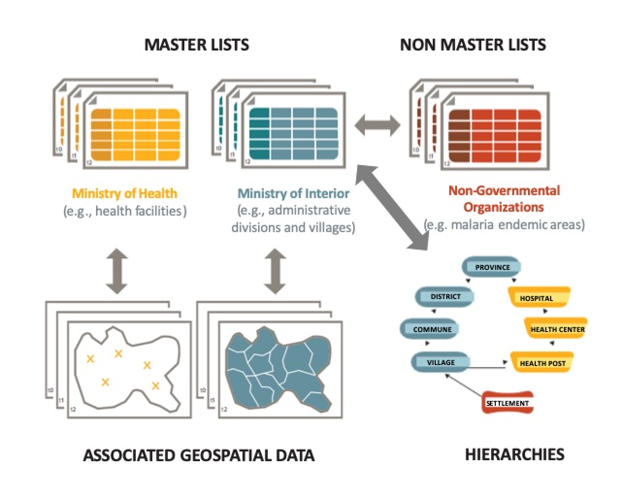
The Common Geo-Registry (CGR), is an IT solution that provides a single source of truth for the standardization, management and use geographic data over time. The CGR is used to stock, manage and share information that are official and non-official, actual and historic, regarding the geographic objects key to sustainable development like administrative divisions, villages, infrastructure and other relevant physical and virtual features forming our environment. The information in questions are lists, hierarchies and geospatial data accessible by any information system or user.
Value Proposition
Everything happens somewhere at a given time. Up-to-date and historical geographic data are necessary to identify areas and populations most at risk for natural disasters or other public health emergencies; to ensure universal coverage of health, education, and other services; and to enable allocation of resources to the right places at the right time in a systematic and data-driven way.
How it works
Use Cases
The CGR supports sustainable development, including public health, education, agriculture and other public and private services by allowing different information systems used in country to:
- Contextualize data from different sources in both time and space
- Use geographic objects as the common link between data sources
- Facilitate trend analysis
- Aggregate data according to different hierarchies
- Support the creation of maps based on the same geography

Important Links

Scalability
The CGR allows to cover all the geographic objects of importance to sustainable development and this across all concerned sectors. Furthermore, there is no limits to the number of information systems that can access the information stored in the CGR or, when applicable, contribute to its update.
Sustainability
The CGR is freely available on GitHub and is built entirely out of open source software components. Long-term maintenance and ongoing improvement of the core technology will be fueled by both public- and private-sector implementations of the CGR, allowing the technology to be partially maintained and enhanced through commercial use, while also taking advantage of open-source developments. Interested parties are encouraged to engage with the open-source community, collaborate, and make code contributions.
CGR Demo Environment (under construction)
URL: Under construction
Login credentials: Under construction
Demo instructions: Under construction
Development Partners
Support for the development of the CGR is provided by the Bill and Melinda Gates Foundation via the Digital Solutions for Malaria Elimination (DSME) Project and the DSME Community. The DSME Project uses geo-enabled information systems to improve the efficiency and effectiveness of malaria surveillance, program planning, and intervention. The DSME Community is a global community of technology organizations, implementers, and subject matter experts who use, or support digital tools in country-led efforts to eliminate malaria. For more information about the DSME Project and Community, please visit: https://dsme.community/